
|
|
 | |
|
On its journey across Virginia to the Atlantic Ocean, the James River takes a northward turn through the rolling Piedmont before swinging to the east again. It hangs its northernmost loop at Scottsville. As winter freshets or heavy rains sluice more water into its course than it can handle, the James River overflows its banks and into Scottsville's low lying downtown. The waters of Mink Creek, which pass by the Methodist Church on Main Street and flows into the James nearby, further added to town flooding. Since 1870, Scottsville has experienced twenty-one floods of 20 feet or more above mean low water level. Flood waters and mud rolled into town, devastating businesses and homes in their path. The Scottsville News and Albemarle Courier, dated August 16, 1940, details actions the town took to minimize loss before an impending flood: "Flood warnings out in Scottsville and all along the James from Lynchburg to Richmond. Reports coming in during Thursday as we go to press say the river is rising a foot an hour, with a 22 foot depth expected here in the morning. Merchants in town are busy moving everything possible out of reach of threatening flood. Back yards of homes on Main Street already under three inches of water. Rain stopped about 4 o'clock in the afternoon, but no sign of a break in the leaden skies." This 1940 flood was only one of many in Scottsville, and there were worse floods to come. In the past century, such devastating floods occurred with more frequency due to several factors. Reduction of timber upriver is a probable factor, allowing rain water to drain off more rapidly and in greater volume. Another contributing factor to flood intensity is silt accumulation on the riverbed. The chart below lists the twenty highest recorded floods of the James River at Scottsville: |
| 1. June 22, 1972 | 34.02 ft. | 11. October 16, 1942 | 23.00 ft. | |
| 2. October 1, 1870 | 30.70 ft. | 12. December 4, 1948 | 22.90 ft. | |
| 3. August 20, 1969 | 30.00 ft. | 13. December 2, 1934 | 22.63 ft. | |
| 4. November 1877 | 27.90 ft. | 14. October 20, 1937 | 22.33 ft. | |
| 5. September 19, 1944 | 26.00 ft. | 15. January 24, 1935 | 22.30 ft. | |
| 6. August 16, 1940 | 25.84 ft. | 16. May 23, 1942 | 21.44 ft. | |
| 7. March 19, 1936 | 25.46 ft. | 17. August 17, 1928 | 20.92 ft. | |
| 8. March 1913 | 25.16 ft. | 18. March 14, 1963 | 20.82 ft. | |
| 9. October 6, 1972 | 23.21 ft. | 19. September 11, 1950 | 20.43 ft. | |
| 10. September 6, 1935 | 23.06 ft. | 20. March 23, 1949 | 20.22 ft. |
|
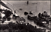
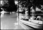
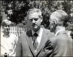
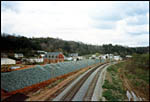
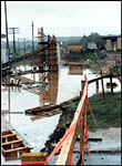
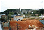
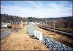
The rains of Hurricane Camille struck Scottsville unmercifully on the evening of August 19, 1969. Ten inches of rain fell before dawn, and some residents on Main Street were evacuated from the second story of their homes by boat. Cars, furniture, fences, and sodden merchandise bobbed about Main and Valley Streets. Before Scottsville could recover from the flood debts incurred from Camille, Hurricane Agnes struck with disastrous results on July 22, 1972. Bruce's Drugstore on Valley and West Main Streets went under more than 12 feet of water as the ensuing flood crested at thirty-four feet. Cleanup costs on top of unpaid 1969 debts put some local businesses in real trouble. Talk of moving the town to higher ground and abandoning buildings in the flood plain was everywhere. Thanks to the efforts of Mayor Raymon Thacker, Scottsville was declared a federal disaster area which made townspeople eligible for loan consolidation and interest rate reduction. Then Mayor Thacker began his tireless quest for federal funding to build a dam on Mink Creek and a flood levee to hold back future flood waters. The impoundment on Mink Creek was completed in 1975, and the A. Raymon Thacker Levee was dedicated in 1990. Scottsville has not been flooded since that date, and the town's economy has slowly revitalized. Below are photos of five destructive floods in Scottsville during the past century. Also shown here are photos of the Scottsville levee construction in November 1985 just as another flood hit town. Please click on each image for a larger view. |
March 1913 and August 1928 Floods | ||||
|
|
|||
| A. Raymon Thacker Collection | ||||
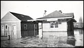
Flood of December 2, 1934 | ||||
 |
 |
|
||
| A. Raymon Thacker Collection | ||||
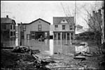
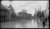
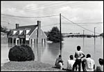
Flood of September 6, 1935 | ||||
 |
|
|
|
|
| Irene and Edward L. Dorrier Collection | ||||
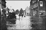
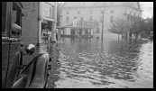
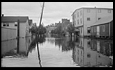
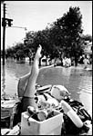
Flood of August 20, 1969 | ||||
 |
 |
 |
 |
|
| A. Raymon Thacker Collection; Photographer, Edwin S. Roseberry, Charlottesville, VA. | ||||
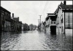
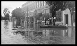
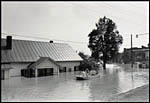
Flood of June 1972 | ||||
 |
 |
 |
||
| A. Raymon Thacker Collection; Photographer, Rip Payne of Charlottesville, VA. | ||||
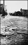
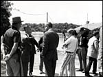
Building the Scottsville Levee, 1985 | ||||
 |
 |
 |
||
 |
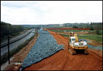 |
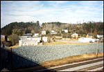 |
||
| A. Raymon Thacker Collection; Photographer, Geneva Denby of Scottsville, VA. | ||||
|
Museum
Archive
Business
Cemeteries
Church
Events
Floods
For Kids
Homes
Portraits
Postcards
School
Transportation
Civil War WWII Esmont Search Policy
|
||||
| Scottsville Museum · 290 Main Street · Scottsville, Virginia 24590 · 434-286-2247 | ||||
|
www.avenue.org/smuseum · info@scottsvillemuseum.com Copyright © 2018 by Scottsville Museum |
||||